
Hi everyone,
After nearly two weeks of fun-filled days of exploring national and state parks and monuments in western Colorado and southern Utah, we drove the 260 miles from Virgin, Utah to Beatty, Nevada. After checking out of our AirBnb (click here for last week’s blog post) we stopped in nearby LaVerkin to stock up on food supplies and fuel. 1-15 took us through St. George (population ~ 85,000) in the far southwest corner of Utah where we stopped for our first Culver’s since leaving Madison. They even had our favorite; salted-carmel-pumpkin concrete mixers. Oh, so delicious! As a bonus, the temperature was warm enough to enjoy our meal outside.
Back on 1-15 to Las Vegas, we navigated some road construction on the north bypass that would take us to Highway 95 and Beatty. For a Saturday, the traffic was heavy, maybe something big was happening in Sin City. We didn’t stick around to find out.
It was in February of 2018 when we were last in Beatty and Death Valley National Park. If anything, Beatty (population about 1000) seemed to be cleaner and brighter. Maybe it was the very friendly clerk at the convenience store or the blue skies and sunshine.
Rhyolite Historic Area
Our purpose in Beatty was to spend the night and then drive the Titus Canyon Road into Death Valley where I would meet up with my photography friends on Sunday evening. We would spend four days photographing the park with guidance from Brenda Tharp and Jed Manwaring. After checking into our hotel room, realizing there was a couple more hours of sunlight, we drove through Beatty, it didn’t take long, and then out four miles west to the ghost town of Rhyolite.
The town sprang up almost overnight with the discovery of gold in the nearby hills. By 1907, Rhyolite boasted a population of about 4000 people. It had a railroad depot, banks, many stores, a hospital, school, a couple of newspapers, even a stock exchange. By the early 1910s, the mines petered out and the people moved on. By 1920, Rhyolite was a ghost town.
Since our visit in February 2018, the Bureau of Land Management that manages the Rhyolite Historic District has surrounded a couple of the remaining buildings with chain link fences. The Depot and The Bottle House now have limited access. We walked around the ghost town viewing what remains, and of course, I snapped a few photos in the fading afternoon sun.


The past four years, I’ve dreaming of making another drive into Death Valley National by way of the Titus Canyon Road. My Traveling Partner, not so much. But she’s a good sport and rode shotgun as we made our way down the 27-mile rocky, pothole filled road. There were times when she looked out her window to a long drop into a canyon! She was happier when her side of the Red Rover was on the mountain side.
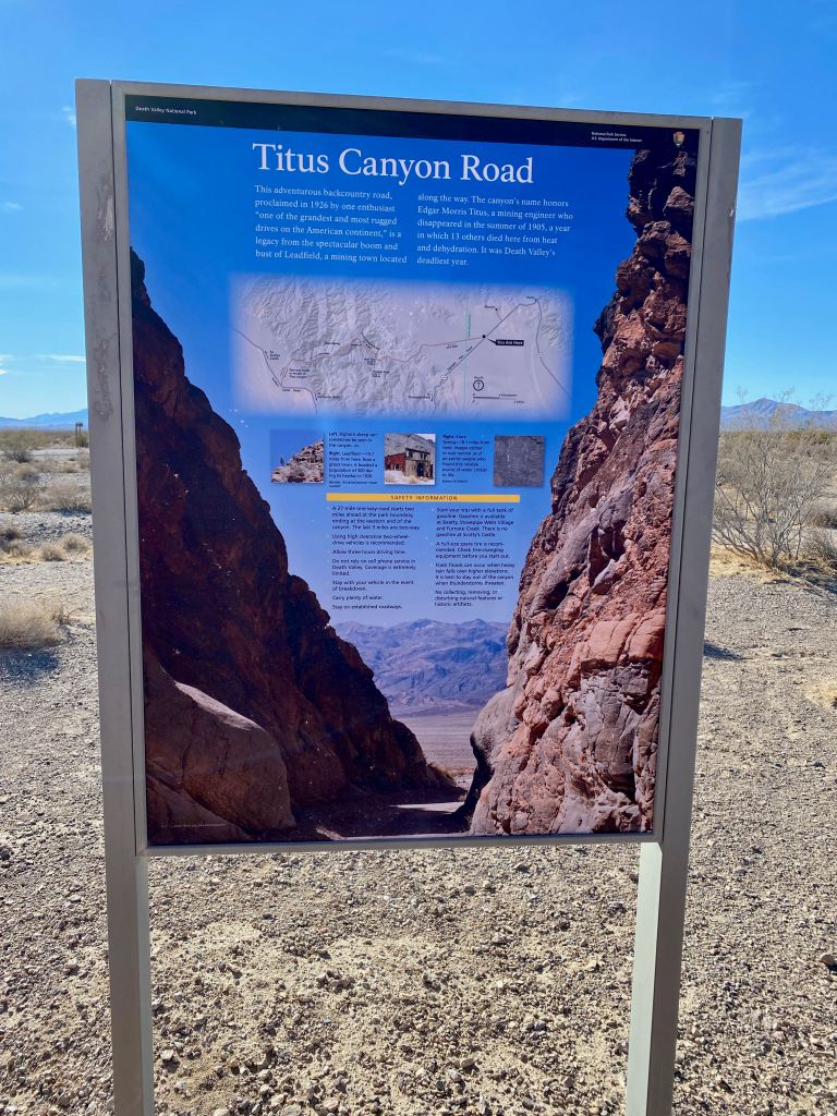
Titus Canyon
Titus Canyon Road begins about 12 miles west of Beatty with a right turn off the highway. Staying on the highway takes visitors into north entrance of Death Valley National Park. Two miles further up Titus Canyon Road, we enter the Nevada portion of the park and the point-of-no return. In other words, the road becomes a one-way.

While the photo above makes the road look like any gravel road in rural America, believe me it’s not! There were times when I engaged 4-wheel-drive on the Red Rover. On the other hand, the road seems improved since we last traveled it in 2018. I drove at a leisurely pace so we could enjoy the fresh mountain air, the warm sun, blue skies, and majestic views. This is one of my favorite parts of Death Valley National Park.

As we made our way through the foothills into the Grapevine Mountains, we stopped periodically to photograph the rock formations and the dry landscape. There were a few vehicles that passed us along the way. One three vehicle caravan was a backcountry tour group in tricked out off-road Jeeps. They looked like they were having a blast. So was I!


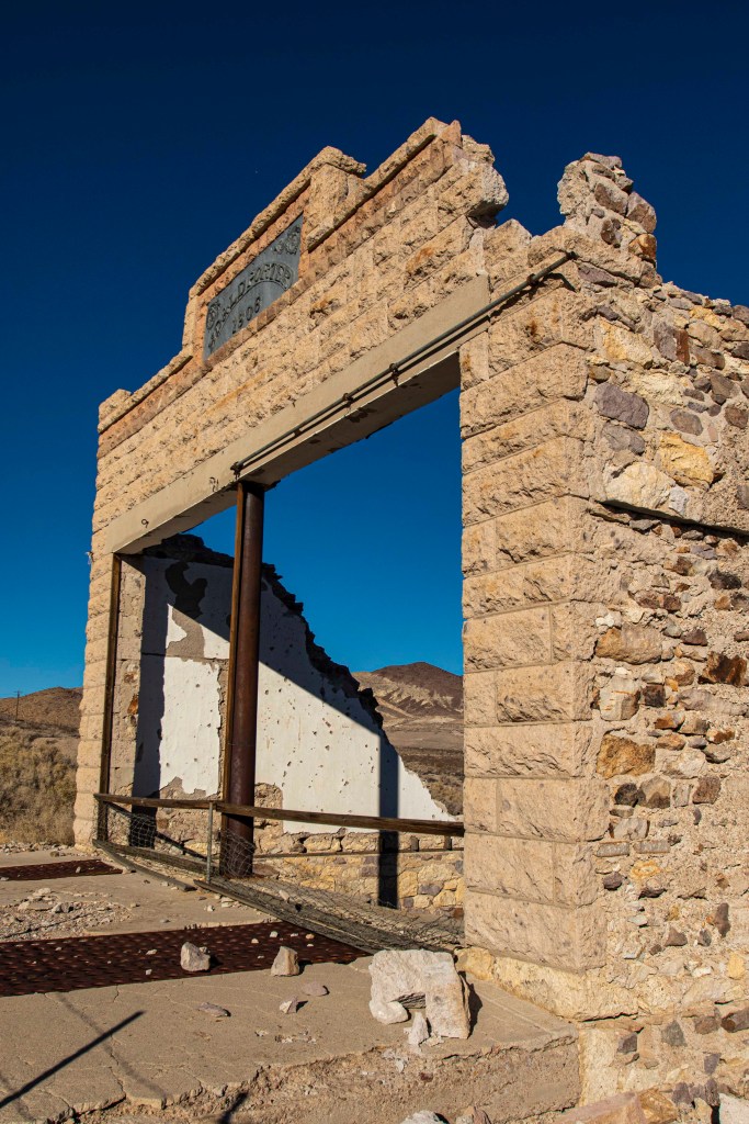
Leadfield
More than halfway on Titus Canyon Road, we came to Leadfield, another ghost town. Its heyday was in the 1920s when a huckster promoted an extensive lead discovery in the nearby hills. It was a fraud. However, for a couple of years Leadfield had a population of about 300 people, even a post office for few months. What remains are a few corrugated steel buildings and a couple of mine shafts, locked for safety reasons. You can still see the remnants of dugouts and a junk yard.


While at Leadfield, we met up with a couple about our age from Waupaca, Wisconsin located about 60 miles northeast of Madison. They noticed our license plates and the Packers shirt I was wearing. While we had a bite of lunch, we chatted back and forth. She was an Air Force veteran and worked as a driver at the King State Veterans Home. In retirement, she delivered fire trucks for a manufacturing company in Oshkosh. It was a fun, chance meeting. We saw them a couple more times as we made our way through Titus Canyon.
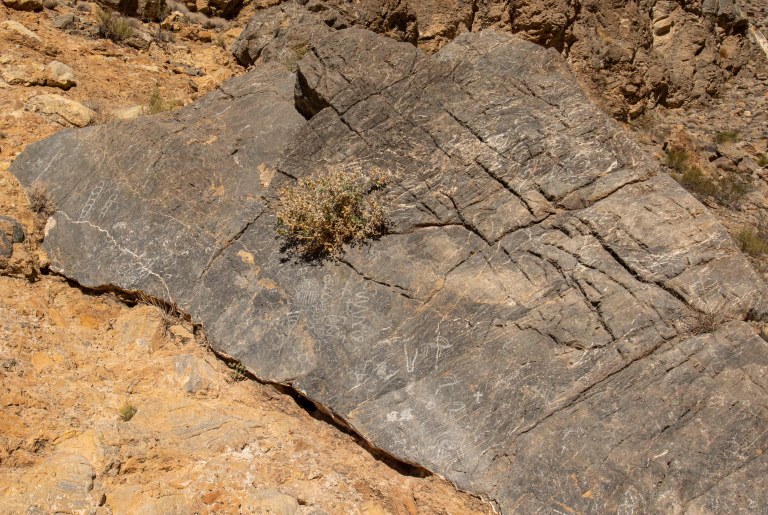
Close to the end of the road, we stopped at the Petroglyphs site created by the Timbisha Native Americans.

The last mile and half of the Titus Canyon Road takes visitors through a narrow, winding canyon with bluish-gray rock walls on either side. I’ll admit it’s a little spooky but beautiful and exhilarating at the same time.


Mesquite Flat Sand Dunes
After exiting the canyon, we stopped at the only restrooms on the entire drive. We met up again with our new friends from Waupaca and chatted some more. After a couple of miles of rough gravel road, we were back on the North Highway headed toward Mesquite Flat Sand Dunes and Stovepipe Wells Village. Since it was a Sunday afternoon, the parking lot at the Dunes was nearly full but we managed to snag a spot right next to our friends from Waupaca! More chatting took place. Then we wandered the Dunes for a bit until the heat drove us back to air conditioning, it was over 90 degrees. I did make a few
decent photos. I would be back at the Dunes later in the week with the photography group.


After a stop for an ice cream bar at Stovepipe Wells, we headed over to Furnace Creek where we would lodge for the next five days. First, we stopped at the Death Valley visitor center to get a stamp in our National Park Passport for the second time. Can’t ever have too many! We also checked out the gift shop and purchased another sticker for the Red Rover. Just outside the entrance, we took a selfie with the temperature. It would be in the 90s the next three days.

Our lodging was at The Ranch at Death Valley, supposedly the budget accommodations in the park. There aren’t a lot of choices, the nearest towns of Beatty and Pahrump, Nevada are 50-60 miles away. The Ranch does have a general store, a couple of shops, a post office, a bar, and restaurant. My Traveling Partner and I settled into our modest room and that evening I met up with the photography group. The last time I was together with them was in 2018 at Taos.
Stay tuned next week for more adventures in Death Valley. In the meantime, click here to learn more about Titus Canyon.
Until then, happy travels!
Tom
Tom, you made even sand flats and rocks look & sound interesting. Thanks for sharing your expertise. Death Valley is fascinating!
Thanks Dottie for your kind words. DV is one our favorite national parks, so big and lots of variety; desert, sand dunes, mountains, craters, salt flats, etc, etc. Stay tuned for more in the next couple of weeks.
Enjoyed. Hope to make the trip, and the beautiful pictures make me want to go. Like knowing their backgrounds.
Thanks for checking in. Death Valley is one of our favorite national parks. So much variety. Stay tuned in the next couple of weeks on more from Death Valley.