
Hi everyone,
It’s a day late but here’s a Merry Christmas to all my readers who celebrate this holiday. May all have relaxing and joyful year end celebrations.
This week I take you to the Needles District in the Canyonlands National Park. This section has fewer visitors than the more easily accessible Island in the Sky District that we visited last week. If you missed that post, click here. However, the Needless is no less spectacular. It’s just more remote, the visitor center is 75 miles south and west of Moab. There are no nearby towns or services so pack a lunch and make sure you have plenty of water on board.
We packed up and left Moab by mid-morning heading south on Highway 191. Our goal was to tour the Needles District and then make our way further south to Blanding where we would bed down for the night. About twenty-five miles south of Moab, we noticed this huge arch close to the highway. It’s Wilson Arch, named after a local pioneer. The opening is over ninety feet wide and nearly fifty feet high. The arch is accessible but there is no dedicated trail to the opening. As you can see in the photo below, four hikers were enjoying the morning view to the east from the arch opening.

About ten miles up the road, we turned off 191 at Church Rock onto UT-211, the access road to Needles. At first our scenery was the high desert along with barbed wire fences and sagebrush. Soon we entered a canyon with low mountains on each side loaded with juniper and pinyon trees. After entering the canyon, we came upon the Newspaper Rock Petroglyphs, a state historic site. It’s one of the largest known collections of petroglyphs with over 650 designs. A boardwalk takes visitors a short distance to the petroglyphs where the variety of ancient figures tickle our imagination as to their meaning. 


Once out of the canyon, we were back on the road to Canyonlands, it’s 22 miles from 191 to the park entrance! I was intrigued by these two rock formation, they looked like pyramids rising out of the desert. The map indicated their names are; South Sixshooter Peak and North Sixshooter Peak. They are so named because they resemble revolvers pointed to the sky. Go figure! Located on Bears Ears National Monument property just over a mile outside of Canyonlands, they rise over 1400 feet above the surrounding landscape. While they look close together, they are actually about a mile and a half apart!

Nearby we saw another rock formation rising out of the nearly flat environment, Bridger Jack Butte. Named for a Paiute medicine man, this formation rises over 700 feet above the surround terrain. It’s noticeable and quite impressive.
We finally reached the park entrance after several stops for photos and gawking at the red rock formations. You’d think we would get tired of seeing similar scenes everyday, but you’d be wrong. Every park and monument was unique in some way from their cousins down the road. They only had red dirt, sagebrush, and rock formations in common.
After stopping to photograph the sign and flash our senior pass at the admissions hut, we proceeded on to the Needles Visitor Center. There were few cars in the parking lot reinforcing the notion that this district of Canyonlands is sparsely visited. Sure it’s more remote but the scenery is excellent, the hiking trails numerous, and sports lots of backcountry roads. 
We learned from talking to the park ranger that this district of Canyonland gets it’s name from this unusual rock formation, The Needles. In the second photo, needles still stand although worn down by thousands of years of water and wind erosion. After our chat with the ranger, we headed out onto the thirteen-mile Scenic Drive. 

About a mile up the road was a turn-off onto a gravel road leading to the 0.6 mile Cave Spring trail. We were the only vehicle in the parking lot. The trail through the brush and rock formation was one-way, we would learn the reason why soon enough.
The first stop on our hike was at the Cowboy Camp tucked into a naturally occurring alcove. This camp was used by cowboys for nearly 100 years as shelter from the hot sun, the monsoon rains of late summer, and the cold winter weather while they tended the cattle under their care. It took about 200 acres to sustain one cow so cowboys had to stay nearby. There was a spring close by that provided a source of water. Before the cattlemen arrived on the scene, this cave was occupied the indigenous peoples as they made their annual migrations, following game and the rain. The blackened ceilings in the cave indicate it has long been used as a place for cooking meals for its occupants.

We continued down the trail until we reached this obstacle. After staring at the ladder for a minute or so, we discussed which way to go: backwards on the one-way trail or climb the ladder. We chose the ladder and were rewarded with two things; another ladder, albeit about half as tall as the one we just climbed and great views once we reached the top of the rock formation.
Here is what we saw once we reached the top of the slickrock (another name for sandstone when it becomes slick after rain). The third photo in this series, shows Wooden Shoe Arch.


It was time for a little lunch when we pulled into the Pothole Point Trail parking lot. There was one other car, they too were having lunch at one of the four or five picnic tables among the juniper and sagebrush. So was this guy, a raven looking for handouts. He and a pesky chipmunk kept inching closer to the tables hoping to scoop up some crumbs. I’m sure we didn’t disappoint but we didn’t intentionally feed them and violate the posted rules about feeding wildlife.

After lunch, we set out on the 0.6 mile Pothole Point trail following the cairns as we walked along. The uneven sandstone surface is dimpled with potholes, a few that contained water even in this very dry climate. The magic of nature is at work here, when it rains the slightly acidic nature of rainwater collects in the potholes and dissolve the rock’s cementing material, making them a bit deeper. Microbes produce a thin film that lines the rock surface, keeping the water from soaking into the sandstone. The standing water then comes to life with mosquito larvae, tiny shrimp, tadpoles, beetles, snails, and other minute creatures. They serve as food for larger animals who then become food for even larger animals like ravens, bats, and coyotes. The web of life continues.

Along our routes, we saw scenes like the one below.
At the end of the Scenic Drive is the Big Spring Canyon Overlook. There were more vehicles in the parking lot as this is the trailhead for the popular hiking trail to the Confluence Overlook, where the Colorado and Green Rivers merge. It’s a ten-mile roundtrip hike with a six-hour completion time. It was too late in the day to set out on this hike. At least that was our excuse! That and we weren’t prepared. So we took a panorama view of the surrounding landscape and inhaled the clean, fresh air.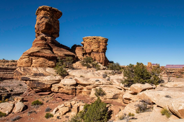


There is a lot more to the Needles, although much of the good stuff is in the more remote sections of the park. Getting to those features requires either an off-road vehicle or a mountain bike or a horse. Maybe next time. All-in-all it was a very enjoyable visit. For more information on Canyonlands Needles District, click here.
Next week, I’m pausing this series to present my year-end Review and Reflections article. Stay tuned on the second Sunday of January for Arches National Park.
Until then, happy travels!
Tom
Merry Christmas to you and Donna. Awesome photos–as usual.
Joyce
Thanks Joyce. All the best to you and your family during this holiday season.